Kannonzaki | One of Ishigaki's Finest Sunset Scenic Spots Complete Guide

When you’re traveling around Ishigaki, the topic of “where shall we watch the sunset?” often comes up. Remote-island sunsets are beautiful everywhere, but among them, the place long loved by locals and travelers alike—as somewhere you can access easily from town and savor the sun sinking into the horizon right in front of you—is Kannonzaki.
Jutting out at the southwestern tip of Ishigaki, this cape is a spot with the atmosphere of a park, dotted with a white lighthouse, an observation deck making use of natural rocks, and large gazebos. Right in front lies Taketomi Island, and turning your gaze west, Kohama Island, with the silhouette of Iriomote Island ranging beyond. Daytime scenery, the dusk sunset, the night’s starry sky—Kannonzaki’s greatest charm is how it changes expression many times within a single day.
What Is Kannonzaki? Ishigaki’s Southwestern Cape
Kannonzaki is a cape located about 6 km west of Ishigaki town, at the tip where the main island of Ishigaki juts out toward the southwest. Geographically, since it’s at the island’s southwestern corner, an open view to the west is secured, and you can gaze at the sun sinking into the horizon almost head-on. This is one reason Kannonzaki is called Ishigaki’s premier sunset spot.
The lucky cape called “Fusagii”

The Kannonzaki area has long been called “Fusaki (Fusagii).” This name, also sung in the Yaeyama folk song “Kohama Bushi,” is a word meaning “good fortune” and “auspicious things,” and it’s a place cherished by islanders as a cape that brings safe voyages. The name Kannonzaki derives from “Tomisaki Kannondo,” located about 600 m east of the cape.
The lighthouse standing on the cape, too, befitting the name Fusagii, has long protected the safety of ships passing offshore. A place where history, nature and faith overlap—that is the cape of Kannonzaki.
Basic information
| Item | Details |
|---|---|
| Official name | Kannonzaki / Fusaki (Fusagii) |
| Address | Arakawa, Ishigaki City, Okinawa |
| Admission | Free |
| Parking | Yes (free, a few spaces. When crowded, use the Tojin Baka parking lot) |
| Restrooms | None (use nearby facilities) |
| From New Ishigaki Airport | About 25 min by car (Route 211 → Prefectural Route 79) |
| From town / Ishigaki Port | About 15–20 min by car, about 30 min by bicycle |
| Access by bus | About 20–30 min from Ishigaki Port Remote-Island Terminal / Bus Terminal to the “Tojin no Haka” bus stop, then on foot |
Kannonzaki’s 3 Great Charms
Some may think, “Is it worth going out of my way for?” In short: yes. And it’s a place that makes you want to come again once you’ve visited. We introduce Kannonzaki’s charms narrowed down to three.
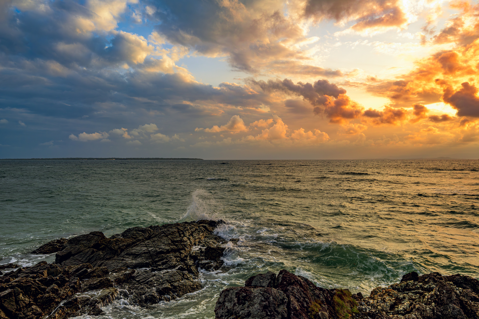
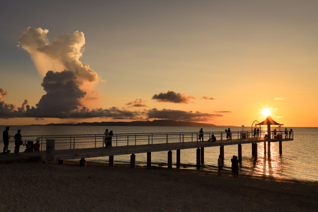
(1) A spectacular sunset sinking into the horizon
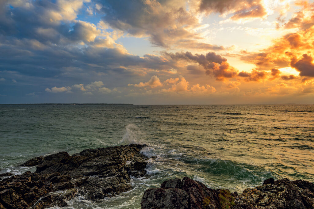
What boasts the greatest popularity at Kannonzaki is, after all, the sunset. Making use of the cape’s terrain opening to the west, you can gaze from the rocky observation deck or gazebos at the sight of the sun slowly sinking toward an unobstructed horizon.
As dusk approaches, the sea’s color shifts from blue to orange, and the whole sky is dyed as if ablaze. The composition with the silhouette of Kannonzaki Lighthouse floating within it has a quiet emotion that the word “photogenic” alone can’t express. The good location—15–20 minutes by car from town—is one reason it’s chosen to cap off Ishigaki sightseeing.
Furthermore, on days when conditions align, you may even see a green flash. A green flash is a natural phenomenon where green light shines for just a few seconds the moment the sun sinks into the horizon, and seeing it is considered lucky. On a clear dusk with crisp air and no clouds, try watching the horizon intently.
(2) A superb view overlooking Taketomi, Iriomote and Kohama Islands
The remote-island scenery viewed from Kannonzaki is also exceptional. Standing on the observation deck built using the rocks, you can clearly see the gentle island shadow of Taketomi Island across the sea right in front. Further to the west are Kohama Island, and beyond it ranges the silhouette of the mountains of Iriomote Island. On a fine day, an open panorama spreads out where you can survey these islands all at once.
Even those who think, “I came to Ishigaki, but I don’t have time to cross to the remote islands,” can feel the overall picture of the surrounding islands just by gazing from Kannonzaki. This scenery, where sea, sky and island shadows overlap, is plenty beautiful even in the blue daytime hours and is worth visiting even if not for the sunset.
(3) A star-filled sky and the lighthouse’s light
Kannonzaki’s charm continues after sunset too. Ishigaki is known as one of Japan’s leading stargazing spots, and even at Kannonzaki, close to town, you can enjoy the sight of countless stars twinkling in the clear night sky. And a special experience unique to Kannonzaki is being able to see the lighthouse’s light and the star-filled sky at the same time. The combination of the regularly rotating lighthouse light and the quietly shining starry sky is a fantastical sight hard to taste elsewhere.
Just by staying on the cape from watching the sunset through to stargazing, you can fully cap off a day in Ishigaki. You can well understand why it’s popular as a date spot for couples and families too.
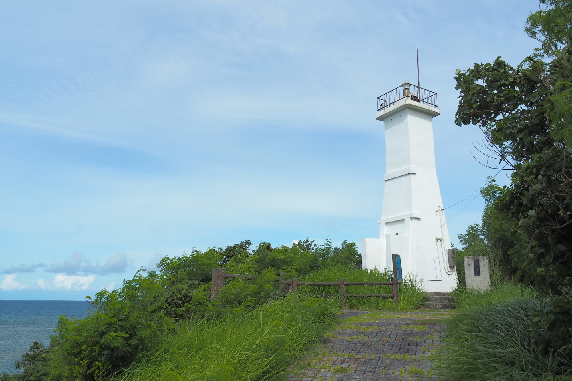
About Kannonzaki Lighthouse
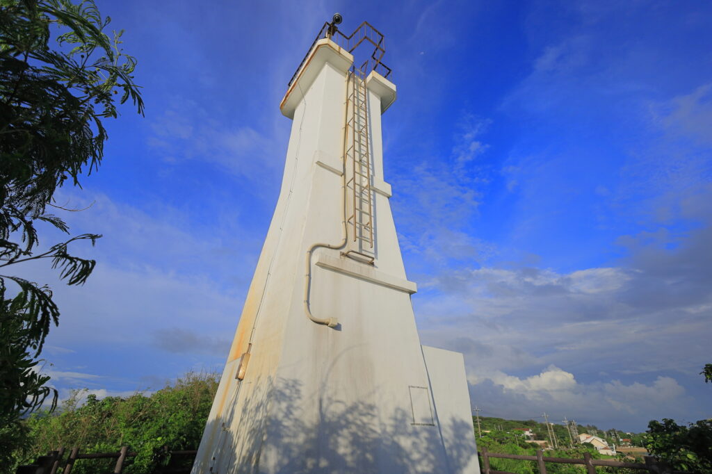
Kannonzaki Lighthouse (Ryukyu Kannonzaki Lighthouse), which can be called Kannonzaki’s symbol, was built in 1953 (Showa 28) by the US military, which then governed Okinawa. It’s one of Ishigaki’s three lighthouses.
| Item | Details |
|---|---|
| Official name | Ryukyu Kannonzaki Lighthouse |
| Year built | 1953 (Showa 28) * rebuilt several times since |
| Height | About 11 m |
| Luminous intensity | 3,500 cd |
| Appearance | A pure-white square lighthouse. A rare shape that isn’t cylindrical |
The stone pillar standing in front of the lighthouse entrance is carved with “Ryukyu Kannonzaki Lighthouse” in kanji, suggesting that Japanese islanders were involved in its construction under US military rule. The lighthouse itself is a compact build, but the sea view gazed at from beyond the narrow path surrounded by grass and trees has a distinctive stillness. Proceeding down the walkway that branches off in front of the lighthouse, you can come out to an open vantage point, reaching a spot where you can survey all the way to Taketomi Island and Iriomote Island.
Sights Around Kannonzaki
One of Kannonzaki’s greatest strengths is that sightseeing spots are concentrated within walking distance. Kannonzaki alone is plenty enjoyable, but by touring the surroundings together, you can experience Ishigaki’s history, culture, nature and activities all in one day.
(1) Tojin Baka
Tojin Baka, located right beside Kannonzaki across the road, is a grave built to mourn the victims of the “Robert Bowne Incident” that occurred in 1852.
This incident was one in which Chinese laborers (coolies) who were about to be sold as slaves from Xiamen (Amoy), China, to America rose in revolt, unable to bear the abuse aboard the ship, and ran aground on the Sakieda Coast near Kannonzaki. 380 people were rescued by Ishigaki’s islanders and officials, but afterward many lives were lost due to the arrival of the British fleet and an American ship, with the dead and missing reaching 128. To console the spirits of these 128 with their sad history, the Chinese-style Tojin Baka was built in 1971.
Though it’s a grave, its vivid colors and Chinese-style ornamentation are striking, and it’s now known as a power spot too. It’s a place where you can feel the depth of Ishigaki’s history and the noble deed of the islanders who carefully protected the victims.
| Item | Details |
|---|---|
| Name | Tojin Baka |
| Address | Arakawa Tomisaki, Ishigaki City, Okinawa |
| Admission | Free |
| Parking | Yes (free, spacious) |
| Distance from Kannonzaki | A short walk (the opposite side across the road) |
(2) Tomisaki Kannondo
Tomisaki Kannondo, located about a 5-minute walk east from Kannonzaki, is a venerable Kannon hall built at its current site around 1742 (Kyoho 27). Said to bring blessings of safe voyages and good health, it’s a place that has continued to stay close to islanders’ lives.
The approach lined on both sides with stone lanterns is striking, and the grounds, surrounded by subtropical plants such as fukugi tree rows and Ryukyu pines, are usually hushed and quiet. However, every New Year it becomes the spot most visited by people in Ishigaki for the first shrine visit, and the line of worshippers forms a long queue. It’s said that over 10,000 worshippers visit in a single day, conveying just how important a place it is to islanders.
| Item | Details |
|---|---|
| Name | Tomisaki Kannondo |
| Address | Arakawa Tomisaki, Ishigaki City, Okinawa |
| Admission | Free |
| Parking | Yes |
| Distance from Kannonzaki | About a 5-minute walk |
(3) Fusaki Beach
Heading about 2 minutes southwest by car from Kannonzaki, there’s Fusaki Beach. A natural beach managed by Fusaki Resort Village, with lifeguards on duty and a jellyfish-prevention net fully equipped, so you can enjoy swimming with peace of mind. The natural environment is so well preserved that sea turtles come to lay eggs every year, and it’s characterized by shallow water and gentle waves. After enjoying the sunset at Kannonzaki, a plan combining it with swimming the next morning is recommended.
| Item | Details |
|---|---|
| Name | Fusaki Beach |
| Address | 1625 Arakawa Tomisaki, Ishigaki City, Okinawa |
| Parking | Yes (free) |
| Facilities | Restrooms & showers, lifeguards on duty, jellyfish net equipped |
| Distance from Kannonzaki | About 2 min by car |
(4) Nagura Bay
Heading a little north from Kannonzaki, there’s Nagura Bay, Ishigaki’s largest bay. Around the bay, mangrove groves centered on Yaeyama mangrove grow wild, and it’s known as a natural environment representative not only of Ishigaki but of Yaeyama. Marine activities such as SUP and sea kayaking are popular, and especially SUP and SUP yoga in the sunset time slot can be enjoyed together with sunset viewing at Kannonzaki.
Access to Kannonzaki and How to Tour the Surroundings
Access to Kannonzaki is most convenient by rental car. Head west on Prefectural Route 79 from town, and you’ll arrive as you proceed with the sea on your left. If using public transport, take a route bus about 20–30 minutes from Ishigaki Port Remote-Island Terminal or the Bus Terminal to the “Tojin no Haka” bus stop, then stroll on foot from there.
| Departure point | Means | Time needed |
|---|---|---|
| New Ishigaki Airport | Rental car (Route 211 → Prefectural Route 79) | About 25 min |
| Ishigaki town / Ishigaki Port | Rental car / taxi | About 15–20 min |
| Ishigaki town | Bicycle | About 30 min |
| Bus Terminal / Remote-Island Terminal | Route bus (alight at “Tojin no Haka” bus stop) | About 20–30 min |
Since the surrounding spots are all gathered within walking distance, touring in the order of Tomisaki Kannondo → Tojin Baka → Kannonzaki Lighthouse → Kannonzaki Observation Deck, with Kannonzaki as your base, lets you tour efficiently. If visiting in the evening, arriving 30 minutes before sunset lets you enjoy the beautiful gradation of sky and sea before sunset too. The way home is often after dark, so take care with your footing.
Even for repeat visitors who have toured Ishigaki’s famous spots once over, Kannonzaki is a place with a hidden-gem feel that makes you think “I want to come again.” It isn’t flashy, but the sea, sky and light speak to you quietly—be sure to add such a Kannonzaki to your travel route.
Book Your Rental Car Here


※For pick-ups or returns outside of business hours, please contact us by phone.
Access
Ishigaki Island Mirais Rent a Car Ishigaki Airport Branch
783-1 Shiraho, Ishigaki City, Okinawa 907-0242, Japan
*The address above shows a wide area. For the exact location, please click “View larger map” or “Open in Google Maps.”
Ishigaki Island Mirais Rent a Car Ishigaki Downtown Branch
704 Tonoshiro, Ishigaki City, Okinawa 907-0004, Japan
*The address above shows a wide area. For the exact location, please click “View larger map” or “Open in Google Maps.”
