Mt. Omoto | Okinawa's Highest Peak, Ishigaki, Hiking Route, Trekking & Access Guide

The answer to the question “Where is Okinawa Prefecture’s highest peak?” is not on the main island, but on Ishigaki. That is Mt. Omoto. Okinawa Prefecture’s highest peak at 525.5 m elevation (526 m in some materials), it’s a special mountain that has gathered faith locally as a sacred mountain since ancient times.
Compared to mainland mountains the elevation is modest, but with the subtropical-specific laurel forest, the large grove of hikagehego tree ferns, 100-year-old itajii giant trees, and a grand panorama from the summit, the climbing satisfaction and appeal are plenty. Be sure to savor the other star of Ishigaki’s two great famous peaks, “Mape and Omoto.” In this article, we’ll deliver a complete guide to Mt. Omoto’s appeal, climbing route, access, and cautions.
What Kind of Mountain Is Mt. Omoto? Okinawa Prefecture’s Highest Sacred Peak
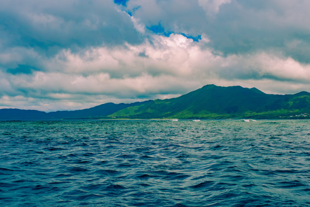
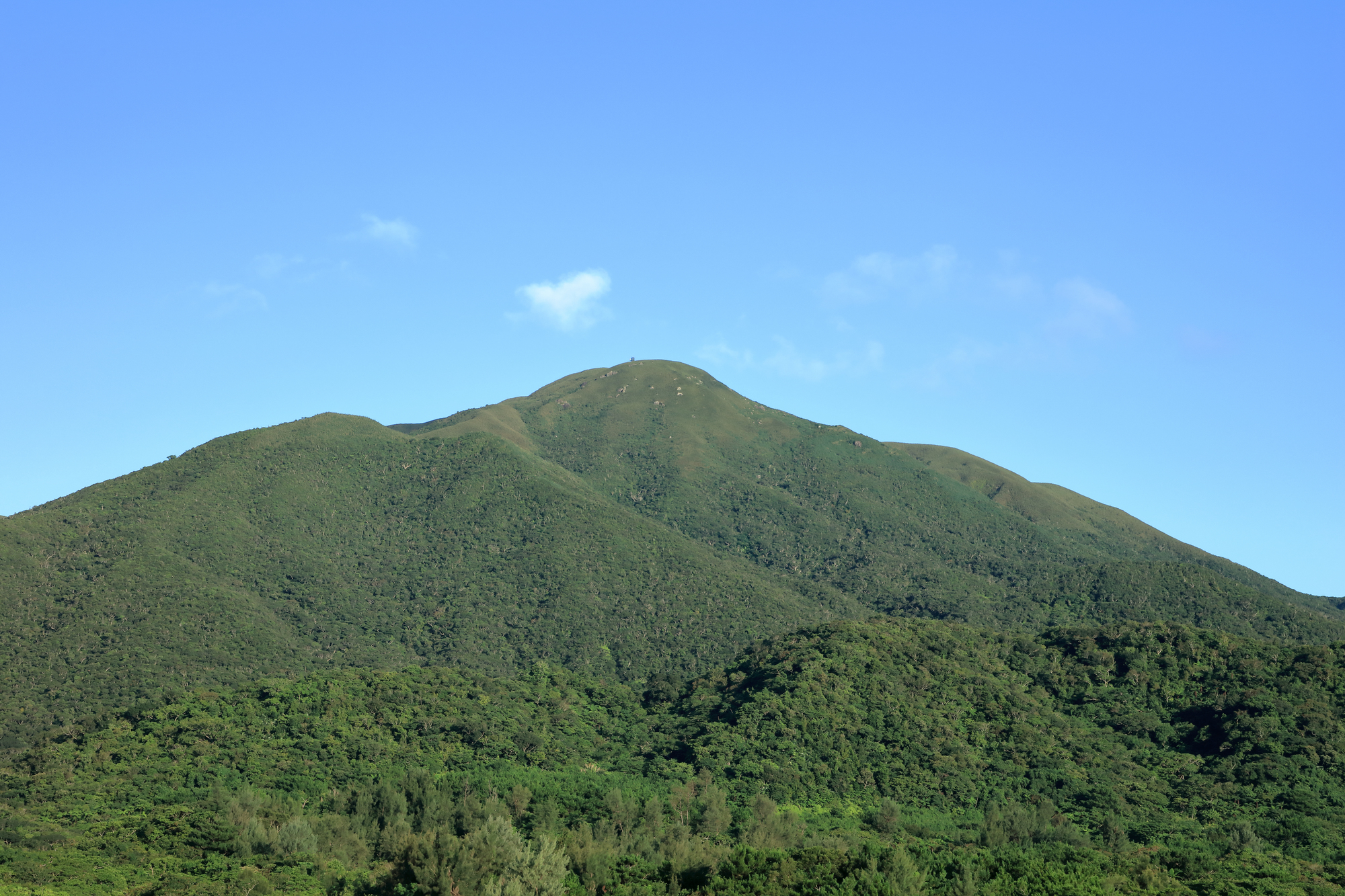
Mt. Omoto is a mountain of 525.5 m elevation (526 m in various materials) towering in north-central Ishigaki. It’s the highest mountain in all of Okinawa Prefecture, and the highest peak of the Yaeyama Islands / Ishigaki too. Beloved by the nickname “Ishigaki Fuji” too, the figure looked up at from the foot shows a dignified mountain form like Mt. Fuji.
This mountain, called “Umutu-dagi” in the Yaeyama dialect. “Umutu” means “great origin (omoto),” and as “the mountain that becomes the island’s great origin,” it has gathered local faith. In the Edo shogunate’s “Shoho Provincial Maps” (1644), it was the only mountain in Ryukyu whose name was recorded—that is Mt. Omoto.
The mountain of three sisters appearing in Ryukyu Kingdom mythology
According to the “Records of the Origins of the Ryukyu Kingdom,” the god of Mt. Omoto is said to be the second of three sisters. The eldest is the god of Bengadake in Shuri, the youngest the god of Kume Island. The second was at first on Kume Island with her younger sister, but because her own mountain was low, she moved to Yaeyama, and furthermore is said to have envied Mt. Omoto as the “island’s guardian deity” and dwelt there.
From such a mythological background, Mt. Omoto has been treasured as a “sacred mountain,” not merely an object of climbing. It’s a mountain you want to climb without forgetting feelings of gratitude to nature and peace at entry and descent.
Okinawa Prefecture’s highest peak | features of geology and vegetation
Mt. Omoto is a mountain made of Neogene granite, covered by a subtropical-specific laurel forest centered on itajii. Near the summit it’s covered by Ryukyu-chiku (a bamboo-grass kin), characterized by becoming tall grassland. You can experience southern vegetation different from mainland mountains.
From the mountain’s middle slope flow out the Miyara River and Nagura River, Ishigaki’s representative rivers, becoming the island’s precious water source too. As “the mountain that supports the island’s life,” it’s a presence where you understand the reason the locals treasure it.
Mt. Omoto Highlights and Appeal

A grand panorama view from the summit
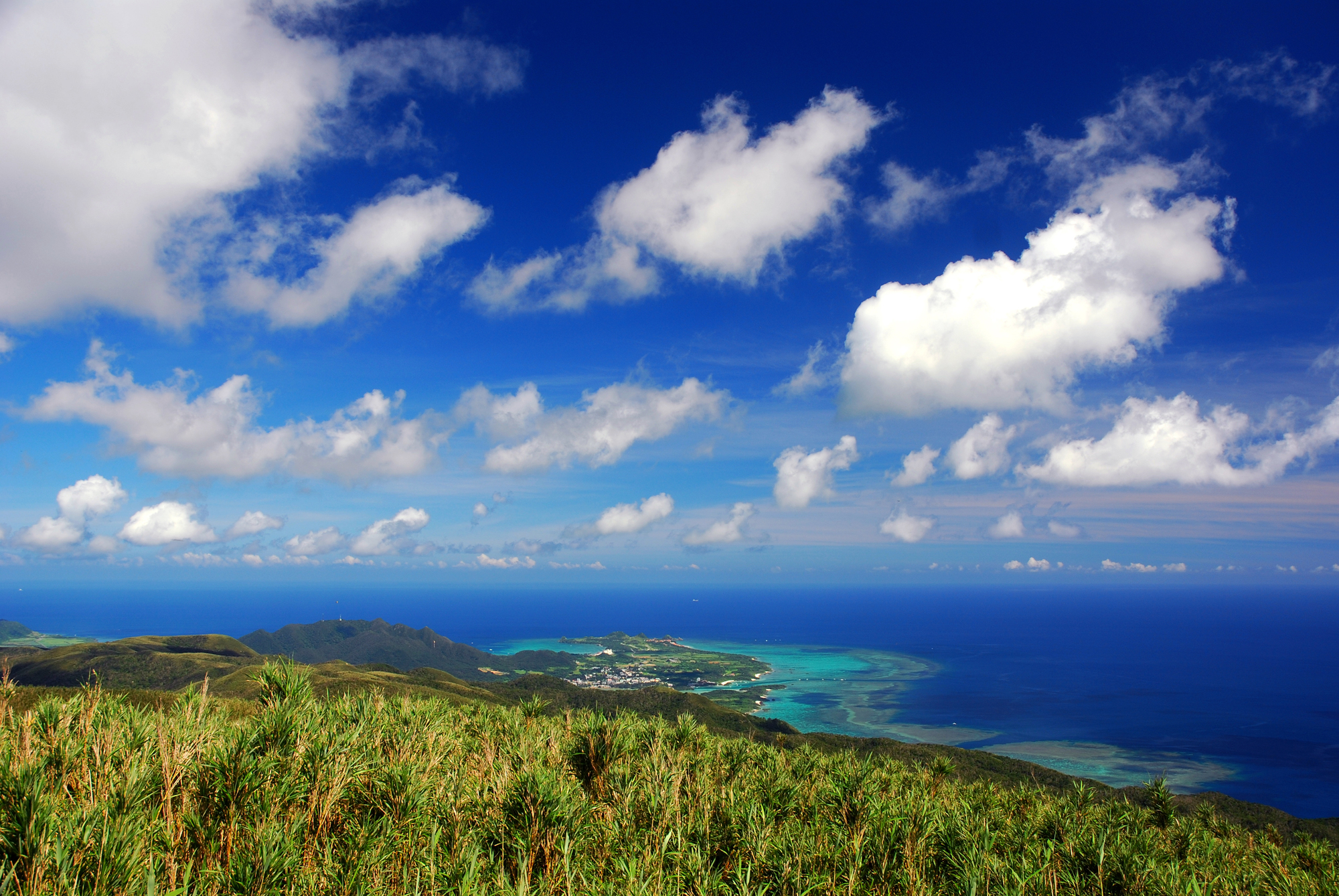
Stand at the summit and a grand panorama spreads out, surveying at a glance the coral-reef sea, Kabira Bay designated a national place of scenic beauty, scattered settlements, and far-off remote islands. The view from 525.5 m elevation is a calm, vast impression, different again from the superb view of a sharp peak like Mt. Nosoko.
On clear days, you can even see far-off remote islands like Hateruma Island—an experience where you truly feel the “top of Okinawa Prefecture.”
The hikageheho and giant-tree forest along the way
Along the climbing route, subtropical-like sights appear one after another—a large grove of hikageheho (subtropical tree fern), itajii giant trees about 100 years old, and mountain wildflowers like camellia and yukokuran. The feeling of walking through a “southern primeval forest” is a precious experience hard to taste on the mainland.
Meeting a green-rich, mountainous Okinawa, different from the “Okinawa = sea” image, is the real pleasure of Mt. Omoto trekking.
Roadside small falls and itajii giant trees
Midway on the climbing trail there are roadside small falls, where you can enjoy refreshing sounds and air. The lush green like a subtropical jungle, the moisture-laden cool air, the sound of the falls—time spreads out where you can feel nature with all five senses.
Mt. Omoto Climbing Route | Full-Fledged Trekking of 1.5 Hours One Way
| Item | Details |
|---|---|
| Elevation | 525.5 m |
| Trailhead elevation | About 100 m |
| Climbing trail | Only one, from the southeast |
| Time needed (one way) | 1 hour–1.5 hours |
| Time needed (round trip) | 2–3 hours |
| Difficulty | ★★★ (even beginners OK, but watch for humidity and slipping) |
The trailhead is only one, on the southeast side
Mt. Omoto’s climbing trail is only one, from the southeast side. There aren’t multiple routes like Mt. Nosoko. The trailhead is in central Ishigaki, deep toward the Maezato Dam direction. Since signs are few, searching for “Mt. Omoto Entrance Parking Space” with a navigation app or a climbing app like YAMAP is certain.
Steep slopes and slippery ground
Mt. Omoto’s climbing trail has many steep slopes and wet ground, and especially near the summit, Ryukyu-chiku taller than your height grows thick and the view narrows too. Trekking shoes and long sleeves / long pants are essential. Since the red soil is very slippery with rain, special care is needed the day after rain or after rain.
Mt. Omoto Basic Information / Access
| Item | Details |
|---|---|
| Location | Ishigaki City, Okinawa |
| Elevation | 525.5 m |
| Nicknames | Ishigaki Fuji, Umutu-dagi |
| Climbing fee | Free |
| Parking | Parking space at the trailhead |
| Restrooms | None |
| Climbing trail | Only one, southeast |
| Departure point | Time needed |
|---|---|
| New Ishigaki Airport | About 20–30 min by car |
| Ishigaki Port Remote-Island Terminal | About 30 min by car |
| Maezato Dam | About 10 min by car |
Rental car essential | no public transport
Access to Mt. Omoto’s trailhead is rental-car essential. Direct access by public transport isn’t possible. Head north on Pref. Route 87 or 209 from New Ishigaki Airport, and proceed relying on the Maezato Dam sign, and you can confirm Mt. Omoto’s entrance.
Since the trailhead’s parking space has few landmarks, setting up navigation with an app like YAMAP, Google Maps, or Yahoo! Car Navi and heading there is certain.
Mt. Omoto Trekking Clothing / Things to Bring
Clothing
- Long sleeves / long pants: measures against scratches from vegetation / insect bites
- Trekking shoes: measures against the slippery trail essential
- Hat: the summit has no shade
- Rainwear: measures against a sudden squall
Things to bring
- Water (1 liter or more, more in summer)
- Light meal / trail food
- Sunscreen
- Insect-repellent spray
- Towel
- Climbing app (measures against getting lost)
- Work gloves
- Change of clothes (sweat / mud measures)
Cautions When Visiting Mt. Omoto
Avoid the May–June rainy season
Okinawa’s rainy season is May–June. Mt. Omoto too has much rain in this period, and the climbing trail turns into a muddy road and becomes very slippery. Choose a clear day, or the comfortable seasons of September–November or March–April are best.
In midsummer, beware heatstroke
Mt. Omoto in summer is extremely high in humidity, becoming a sweat-drenched climb. Thoroughly do an early-morning start, frequent hydration, and sunburn measures. A 6–7 a.m. start is recommended.
Watch for habu and pit vipers
Habu inhabit the mountains of Ishigaki. Take measures like not carelessly entering the bushes, protecting your skin with long sleeves / long pants. In preparation for the unlikely event of being bitten, confirming a climbing notification and emergency contact is important too.
Don’t forget respect for the sacred mountain
Mt. Omoto is a sacred mountain revered locally. Observe manners like always taking trash home, not collecting plants, and not being loud, and climb with respect.
Nearby Spots to Enjoy Together with Mt. Omoto
Arakawa Falls | a natural pool of the source
The Arakawa River, with Mt. Omoto as its source, has Ishigaki’s only waterfall, “Arakawa Falls.” Dropping by after climbing and cooling down with water play is recommended.
Yonehara Yaeyama Palm Grove | the world’s most beautiful palms
Yonehara Yaeyama Palm Grove, about 20 minutes by car from Mt. Omoto. A Natural Monument where Yaeyama palms, called the world’s most beautiful, grow in a grove.
Kabira Bay | a Michelin three-star superb view
Kabira Bay, about 30 minutes by car from Mt. Omoto. Ishigaki’s greatest superb-view spot, visible from the summit too.
Banna Park | an emerald superb view
Banna Park, about 20 minutes by car from Mt. Omoto. A forest park close to town, where you can enjoy a superb view from the observation decks too.
Mt. Omoto FAQ
Can even beginners climb it?
Compared to mainland mountains it’s an easier mountain to climb, but since there are steep grades and slippery ground, the completely inexperienced should take care. Shoes at the sneaker level or above, and minimal physical strength, are needed.
How long does it take?
From trailhead to summit, 2–3 hours round trip. If combining with sightseeing, a half-day plan is recommended.
What’s the best season?
March–April, September–November. Avoiding the rainy season and midsummer, climbing is possible through the year. Since there’s no snow even in winter, you can climb.
Can I climb it with kids?
It’s possible from elementary school up, but since there are steep-grade scenes too, physical strength and prudence are needed. For a family climb, the easier Mt. Nosoko is recommended first.
Is there a guided tour?
Since it’s a minor mountain, guided tours aren’t as many as Mt. Nosoko. Inquire with an outdoor shop in advance.
Summary | Challenge Okinawa Prefecture’s Highest Sacred Peak at Mt. Omoto
Mt. Omoto is Okinawa Prefecture’s highest peak at 525.5 m elevation, a sacred mountain with the nickname Ishigaki Fuji. The subtropical itajii laurel forest, the large grove of hikageheho, the superb view of the coral-reef sea and Kabira Bay from the summit—it’s a spot where you can meet the appeal of a green-deep southern mountain, overturning the “Okinawa = sea” image.
About 20–30 minutes by car from New Ishigaki Airport, the climbing trail is only one in the southeast, the time needed 1.5 hours one way. Care is needed for the slippery red soil and steep grades, but if you prepare your equipment firmly, it’s a friendly mountain even beginners can summit.
Pay respect to the sacred mountain that supports the island’s life, and climb while treasuring the encounter with nature—be sure to experience such a journey on your next Ishigaki visit. Surely it’ll become an unforgettable Okinawa mountain trip.
Book Your Rental Car Here


※For pick-ups or returns outside of business hours, please contact us by phone.
Access
Ishigaki Island Mirais Rent a Car Ishigaki Airport Branch
783-1 Shiraho, Ishigaki City, Okinawa 907-0242, Japan
*The address above shows a wide area. For the exact location, please click “View larger map” or “Open in Google Maps.”
Ishigaki Island Mirais Rent a Car Ishigaki Downtown Branch
704 Tonoshiro, Ishigaki City, Okinawa 907-0004, Japan
*The address above shows a wide area. For the exact location, please click “View larger map” or “Open in Google Maps.”
